SEMAINE VELO 2024 - SAULIEU (Bourgogne - France) 4 MAI - 11 MAI
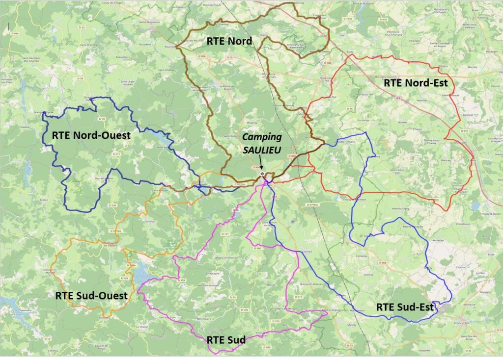
TOUS LES PARCOURS ROUTE Boucles avec DEPART/ARRIVEE CAMPING "Aquadis Loisirs" (Saulieu)
Les parcours sont construits sur les points cardinaux :
Nord-Est / Sud-Est / Sud / Nord-Ouest / Sud-Ouest / Nord
du dimanche 5 mai au vendredi 10 mai 6 parcours proposés chacun décliné sur le modèle "Grand (GD)" ou "Petit (pt)"
---------
DIMANCHE 5 mai
Parcours : NORD-EST
Parcours NORD-EST Petit
Map of the route “Semaine Cyclo 2024 Parcours Route”: 70,28 km, 721 m of climbing and 723 m of descent, elevation between 324 m and 539 m. It is a loop that starts and ends at 47.28949, 4.22352 (latitude, longitude).
Total distance: 70.35 km Max elevation: 539 m Min elevation: 324 m Total climbing: 721 m
Map of the route “Semaine Cyclo 2024 Parcours Route”: 83,09 km, 787 m of climbing and 789 m of descent, elevation between 305 m and 539 m. It is a loop that starts and ends at 47.28949, 4.22352 (latitude, longitude).
Total distance: 83.11 km Max elevation: 539 m Min elevation: 305 m Total climbing: 787 m
Map of the route “Semaine Cyclo 2024 Parcours Route”: 68,92 km, 765 m of climbing and 764 m of descent, elevation between 346 m and 544 m. It is a loop that starts and ends at 47.28899, 4.22344 (latitude, longitude).
Total distance: 68.98 km Max elevation: 544 m Min elevation: 346 m Total climbing: 765 m
Map of the route “Semaine Cyclo 2024 Parcours Route”: 83,09 km, 932 m of climbing and 930 m of descent, elevation between 329 m and 544 m. It is a loop that starts and ends at 47.28899, 4.22344 (latitude, longitude).
Total distance: 83.15 km Max elevation: 544 m Min elevation: 329 m Total climbing: 932 m
Map of the route “Semaine Cyclo 2024 Parcours Route”: 69,00 km, 1 018 m of climbing and 1 017 m of descent, elevation between 382 m and 703 m. It is a loop that starts and ends at 47.28940, 4.22509 (latitude, longitude).
Total distance: 69.01 km Max elevation: 703 m Min elevation: 381 m Total climbing: 1018 m
Map of the route “Semaine Cyclo 2024 Parcours Route”: 81,47 km, 1 189 m of climbing and 1 189 m of descent, elevation between 359 m and 707 m. It is a loop that starts and ends at 47.28940, 4.22509 (latitude, longitude).
Total distance: 81.69 km Max elevation: 707 m Min elevation: 359 m Total climbing: 1189 m
Map of the route “Semaine Cyclo 2024 Parcours Route”: 67,54 km, 1 069 m of climbing and 1 065 m of descent, elevation between 389 m and 661 m. It is a loop that starts and ends at 47.28917, 4.22391 (latitude, longitude).
Total distance: 67.69 km Max elevation: 661 m Min elevation: 388 m Total climbing: 1069 m
Map of the route “Semaine Cyclo 2024 Parcours Route”: 85,04 km, 1 378 m of climbing and 1 373 m of descent, elevation between 313 m and 661 m. It is a loop that starts and ends at 47.28917, 4.22391 (latitude, longitude).
Total distance: 85.19 km Max elevation: 661 m Min elevation: 313 m Total climbing: 1378 m
Map of the route “Semaine Cyclo 2024 Parcours Route”: 69,94 km, 1 023 m of climbing and 1 021 m of descent, elevation between 481 m and 695 m. It is a loop that starts and ends at 47.29067, 4.22576 (latitude, longitude).
Total distance: 69.94 km Max elevation: 695 m Min elevation: 481 m Total climbing: 1023 m
Map of the route “Semaine Cyclo 2024 Parcours Route”: 83,18 km, 1 334 m of climbing and 1 332 m of descent, elevation between 455 m and 695 m. It is a loop that starts and ends at 47.29067, 4.22576 (latitude, longitude).
Total distance: 83.18 km Max elevation: 695 m Min elevation: 455 m Total climbing: 1334 m
Map of the route “Semaine Cyclo 2024 Parcours Route”: 68,62 km, 697 m of climbing and 698 m of descent, elevation between 262 m and 596 m. It is a loop that starts and ends at 47.28917, 4.22391 (latitude, longitude).
Total distance: 68.76 km Max elevation: 597 m Min elevation: 262 m Total climbing: 697 m
Map of the route “Semaine Cyclo 2024 Parcours Route”: 83,42 km, 808 m of climbing and 810 m of descent, elevation between 262 m and 596 m. It is a loop that starts and ends at 47.28917, 4.22391 (latitude, longitude).
Total distance: 83.45 km Max elevation: 597 m Min elevation: 262 m Total climbing: 808 m