SEMAINE VELO 2024 - SAULIEU (BOURGOGNE) 4 MAI - 11 MAI
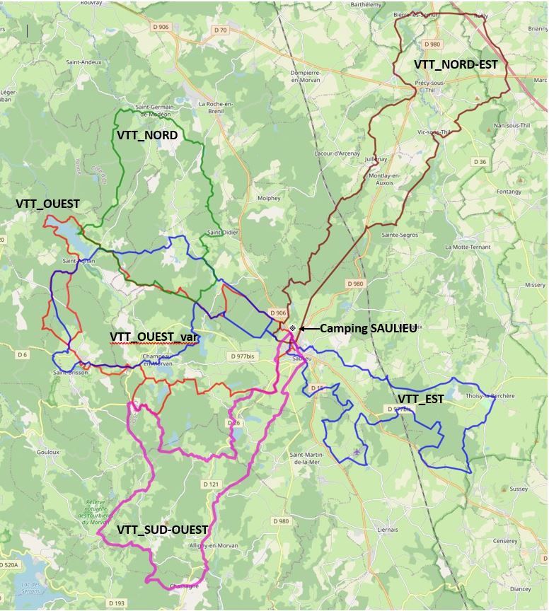
Tous les parcours VTT autour de SAULIEU avec quelques variantes
---------
Secteur NORD-EST
# BIERRES LES SEMURS #
Map of the route “Semaine Cyclo 2024 Parcours VTT”: 49,41 km, 648 m of climbing and 646 m of descent, elevation between 309 m and 564 m. It is a loop that starts and ends at 47.28454, 4.22656 (latitude, longitude).
Total distance: 49.43 km Max elevation: 565 m Min elevation: 309 m Total climbing: 648 m
Map of the route “Semaine Cyclo 2024 Parcours VTT”: 43,98 km, 512 m of climbing and 513 m of descent, elevation between 389 m and 587 m. It is a loop that starts and ends at 47.28982, 4.22493 (latitude, longitude).
Total distance: 43.98 km Max elevation: 587 m Min elevation: 389 m Total climbing: 512 m
Map of the route “Semaine Cyclo 2024 Parcours VTT”: 48,23 km, 765 m of climbing and 765 m of descent, elevation between 456 m and 689 m. It is a loop that starts and ends at 47.28992, 4.22482 (latitude, longitude).
Total distance: 48.3 km Max elevation: 689 m Min elevation: 456 m Total climbing: 765 m
Map of the route “Semaine Cyclo 2024 Parcours VTT”: 41,42 km, 620 m of climbing and 620 m of descent, elevation between 456 m and 643 m. It is a loop that starts and ends at 47.28992, 4.22482 (latitude, longitude).
Total distance: 41.53 km Max elevation: 644 m Min elevation: 456 m Total climbing: 620 m
Map of the route “Semaine Cyclo 2024 Parcours VTT”: 43,87 km, 572 m of climbing and 570 m of descent, elevation between 521 m and 659 m. It is a loop that starts and ends at 47.29015, 4.22499 (latitude, longitude).
Total distance: 44.05 km Max elevation: 659 m Min elevation: 521 m Total climbing: 572 m
Map of the route “Semaine Cyclo 2024 Parcours VTT”: 48,46 km, 723 m of climbing and 721 m of descent, elevation between 521 m and 681 m. It is a loop that starts and ends at 47.29015, 4.22499 (latitude, longitude).
Total distance: 48.5 km Max elevation: 681 m Min elevation: 521 m Total climbing: 723 m
Map of the route “Semaine Cyclo 2024 Parcours VTT”: 30,82 km, 431 m of climbing and 426 m of descent, elevation between 377 m and 619 m. It is a loop that starts and ends at 47.30988, 4.17863 (latitude, longitude).
Total distance: 30.85 km Max elevation: 619 m Min elevation: 377 m Total climbing: 431 m
Map of the route “Semaine Cyclo 2024 Parcours VTT”: 41,34 km, 542 m of climbing and 542 m of descent, elevation between 377 m and 619 m. It is a loop that starts and ends at 47.28967, 4.22478 (latitude, longitude).
Total distance: 41.38 km Max elevation: 619 m Min elevation: 377 m Total climbing: 542 m